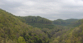
The APPALACHIAN "MOUNTAINS"
 The
Appalachian Mountains are not changeless, monolithic sentinels that have
stood in their present form since their creation. Rather, they are worn-away
remnants of a once-high alpine plateau-- worn away like the teeth of an
old horse by the elements of wind, rain, and ice over the past 200 million
years.
The
Appalachian Mountains are not changeless, monolithic sentinels that have
stood in their present form since their creation. Rather, they are worn-away
remnants of a once-high alpine plateau-- worn away like the teeth of an
old horse by the elements of wind, rain, and ice over the past 200 million
years.
What are today the coalfields of southern West Virginia were once a high plateau rising to heights of as much as 10,000 to 18,000 feet above sea level. This odd, Tibetan landscape was flanked on the south and east by the even higher Alleghenian Mountain range, which likely exceeded the Himalaya's in height.
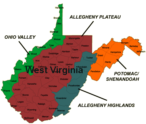 The Allegheny Highlands today rise only 3,000-6,000
feet in elevation, and the adjacent Allegheny Plateau to the west-- now
reduced to a mosaic of twisted drainage courses separated by erosional
remnants unapologetically also called "mountains"-- reaches elevations
of only about 1,000-2,500 feet. Miners who work parts of these ridges for
the coal they contain and in the process fill some of the intervening hollows
and valleys are actually restoring parts of the Allegheny Plateau to its
"approximate original contour." Their efforts are criticized
by eco-activists who see the mountains as a static gift from Gaia and dismiss
the notion that all but the tiniest remnants of this landscape, and its
treasure of coal riches have already been transported away by erosion to
the Gulf of Mexico.
The Allegheny Highlands today rise only 3,000-6,000
feet in elevation, and the adjacent Allegheny Plateau to the west-- now
reduced to a mosaic of twisted drainage courses separated by erosional
remnants unapologetically also called "mountains"-- reaches elevations
of only about 1,000-2,500 feet. Miners who work parts of these ridges for
the coal they contain and in the process fill some of the intervening hollows
and valleys are actually restoring parts of the Allegheny Plateau to its
"approximate original contour." Their efforts are criticized
by eco-activists who see the mountains as a static gift from Gaia and dismiss
the notion that all but the tiniest remnants of this landscape, and its
treasure of coal riches have already been transported away by erosion to
the Gulf of Mexico.
Coal seams in West Virginia were deposited 320 - 286 million years ago, in a physiographic setting that was a complex of vast coastal swamplands barely rising above sea level. Layer by layer fans of sediments were deposited here by rivers sourced from the east from highlands now long gone. These coastal swamps and river deltas sank ever deeper, as layers of sand and mud were deposited, along with occasional coal beds-- piling up many thousands of feet of sediments which grew hotter as they sank deeper. Coal seams can be used as a sort of thermometer, indicating by their coal rank the deepest depths to which they and the rock layers that surround them have been buried.
The earth exerts an average geothermal gradient of about 1.5° F for every 100 feet of burial depth. As coal seams are depressed ever-deeper into the earth under accumulating sediments, much of the water and volatile matter are driven away, leaving behind the fixed carbon as well as residual amounts of ash, sulfur, and tiny amounts of a few assorted trace elements. The extent of this de-volatilization varies according to the deepest depth of ultimate burial, resulting in a continuous series of coal grades, ranked according to the relative percentages of fixed carbon they contain.
|
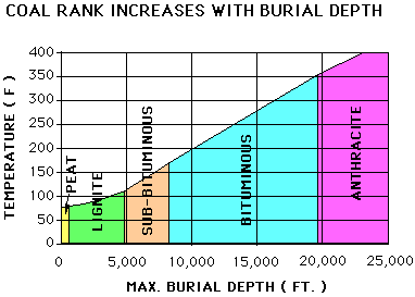 In the absence of volcanic action or geology-deforming
tectonism, coals buried in a normal geothermal gradient will achieve bituminous
rank at burial depths ranging between 8,500 and 20,000 feet. As coal beds
are buried deeper the volatile matter and moisture gets cooked away, leaving
behind the fixed carbon. Very deep burial, and/or volcanic/tectonic
activity, produce anthracite coals.
In the absence of volcanic action or geology-deforming
tectonism, coals buried in a normal geothermal gradient will achieve bituminous
rank at burial depths ranging between 8,500 and 20,000 feet. As coal beds
are buried deeper the volatile matter and moisture gets cooked away, leaving
behind the fixed carbon. Very deep burial, and/or volcanic/tectonic
activity, produce anthracite coals.
Low-vol bituminous coals result when burial depths approach 15,000- 20,000 feet. These coals are valuable as coking coals used in steel-making.
High-vol bituminous coals are formed at shallower depths-- 8,500 to 15,000 feet. These are used mostly for producing steam for electrical generation, as are the sub-bituminous and lignite coals which are found in other regions of the U.S.
Because of their higher fixed carbon content and lower moisture content, bituminous coals contain more energy per pound than sub-bituminous coals, which in turn contain more energy than lignite coal. In the U.S., this heat energy is typically expressed as BTU's (British Thermal Units) per pound. A typical pound of bituminous coal from West Virginia will yield about 12,000 BTU's of energy.
The generally flat-lying bituminous coal beds which are layer-caked throughout the West Virginia coalfields were each in their turn deposited near sea level, depressed thousands of feet by accumulating sediments, and today rest at elevations ranging from 0 to 3,000 feet. By virtue of the "coal-rank thermometer" we know this region was elevated 15,000 to 23,000 feet by the end of the Alleghenian Orogeny. Erosion was contemporaneous, though the precise rates are uncertain, resulting in probable maximum actual elevations of between 10,000 and 18,000 feet. This physiographic Tibet known as the Allegheny Plateau was upthrust 250 million years ago from the great wedge of deltaic sediments deposited during the earlier Devonian and Carboniferous geologic periods.
Although West Virginia was near the tropics during Permian time, this towering, alpine plateau likely supported glaciers that gouged out craggy mountain peaks and alpine valleys. Today, there are no glaciers, no craggy peaks. In fact, there were not glaciers at all in West Virginia during any of the Pleistocene Ice Ages. There are technically no true "mountains" in the southern coalfields of West Virginia at all-- rather a schizophrenic landscape of steep ridges and twisting drainages reduced by the elements to diminutive erosional fenders and gullies etched into the roots of the once-mighty Allegheny Plateau.
The driving tectonic forces that produced these former highlands were
the continental collisions that occurred during
Pennsylvanian and Permian time, when the continents of South America and
Europe smashed slow-motion into the east coast of North America, to form
the supercontinent known as Pangea.
CREDITS:
Data adapted from: New Zealand Mining Industries Association
Physiographic map courtesy of West Virginia Tourism Careers